The Relative Hills Society has adopted several Hill Lists of Great Britain including the Marilyns, Humps and Tumps which are based on the PROMINENCE of the hills RELATIVE to adjacent hills. The theory of Prominence can get a little complicated, but the diagram below explains it, hopefully, for a fairly simple example.
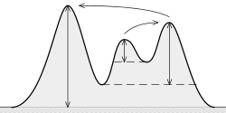
Vertical arrows show the topographic prominence of three peaks on an island. The dashed horizontal lines show the lowest contours that do not encircle higher peaks. Curved arrows point from a peak to its parent.
The highest peak’s prominence is its actual height above sea level since there is no higher mountain on the island. The second highest peak’s prominence is measured relative to its col with the highest peak whereas the lowest hill’s prominence is measured relative to its col with the second-highest peak.
Typically, in Britain, that could mean that the highest hill is a Marilyn (P150) whilst the second hill is a Hump (P100) and the third hill is a Tump (P30). Numerous examples of this hierarchy can be found around the country.For a deeper understanding of Prominence, see the Wikipedia page for Topographic prominence.
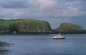 The Shiant Isles off the Island of Lewis in the Outer Hebrides. Garbh Eilean at centre left is a Marilyn (P160), the hill on the right is Eilean an Tighe, a Hump (P123), whilst at the far left is Glaic na Crotha, a Tump (P40). The Shiants are home to one of the largest puffin populations in the world.